Monday, May 14, 2012

7 Weird Micronations of the World

micronation is a tiny, self-proclaimed sovereign state. Though they claim sovereignty and are often not interfered with by larger government entities, they are not recognized as official independent states (which sets them apart from microstates like The Vatican orSingapore.) There are any number of reasons someone may start a micronation: as a joke, as a form of art, for protest purposes, as a political or legal experiment, or even to conduct criminal activity. Often times a strange legal quirk (or outright loophole) gives these micronations a unique legal status. Some of them are hilarious. Some of them are interesting. Most of them are, in their own way, bizarre, unique, and strange.

1. Principality of Sealand
Size: 0.00055 km2
Population: 27 (2002 estimate)
Ruler: Michael Bates


Sealand is probably the world’s most well known micronation, and this is probably because the stories behind it are bizarre and truly intriguing. The site of Sealand is about 10 km off the coast of England, and was originally a World War II sea fort designed to deter German air raids. In 1967Paddy Roy Bates occupied the sea fort (then called Knock John) and used it to run an off-shore pirate radio station. He and his family have claimed it as an independent sovereign nation, including issuing passports. Bates claimed that the nation was granted de facto statehood when Germany sent a diplomat there, and a 1968 UK court ruling stated that because of its location in international waters, it is outside of British jurisdiction. This is connected to what is perhaps the most fascinating event in Sealand’s history, which took place in 1978. While Bates was away, Alexander Achenbach, who refers to himself as the Prime Minister of Sealand, along with several German and Dutch compatriots, staged an armed takeover of the facility.
They held Bates’s son, Michael, hostage for several days, later releasing him in the Netherlands. Bates enlisted armed help to aid him in recapturing Sealand, and raided it from helicopters. He held Achenbach and the others as prisoners of war, and while the others were released, Achenbach was not. Since he held a Sealand passport, he was charged with treason against the micronation and was held unless he paid a hefty fine. When the British government would not help, Germany sent a diplomat to negotiate his release. From time to time, rather extreme things like this have happened at Sealand, including an instance in 1990 in which a British ship was fired upon with rifles from Sealand for passing too close and “invading Sealand territory”. It was notably in the news once more in 2007, when torrenting gurus The Pirate Bay attempted to buy it in reaction to harsher copyright restrictions in Sweden, its homebase.

2. Republic of Molossia
Size: 58 km2
Population: 2-3
Ruler: President Kevin Baugh
photo source
Molossia is headquartered just outside of Dayton, Nevada, and consists of President Kevin Baugh’s homeback and front yards, and two properties he purchased in Pennsylvania and California. He styles himself after a dictator, right down to the military uniform and big sunglasses, and his micronation has been described as “a hobby taken to the nth degree.” He also claims a spot in the Pacific Ocean and 49,881 square miles on Venus. Molossia pays taxes to the United States, but officially labels this as “foreign aid”. A variety of bizarre things are banned in Molossia, including: guns, walruses, catfish, onions (and onion-like vegetables), and anything from Texas except pop star Kelly Clarkson.

3. Principality of Hutt River
Size: 75 Km2
Population: Around 20 residents and 13,000-18,000 overseas citizens
Ruler: His Royal Highness Prince Leonard I
Prince Leonard Casley at Hutt River Province    photo source
The Principality of Hutt River (formerly Hutt River Province) was founded by Leonard Casley in 1970. The micronation was formed when the five families owning farms in the Hutt River area became involved in a legal dispute with the government of Western Australia over wheat farming quotas. Essentially, the families had produced an amount of wheat that greatly exceeded what they were told they could legally sell under a new law (1,000 times the allowed amount, in the case of Casley himself).

In correspondence with the Governor, Casley was addressed as “The Administrator of the Hutt River Province”, legally entitling him to that title. He changed his title to “His Royal Highness Prince Leonard I” to take advantage of an old law stating that anyone interfering with a royal could be held for treason, and used this to justify seceding from Australia. In1976, Australia Post stopped handling mail for the micronation, and repeated demands were made that the residents of Hutt River Province pay Australian taxes. Casley declared war on Australia as a result, and the mail began to run again (and the tax notices stopped coming.)

4. Other World Kingdom
Size: 0.02 km2
Population: Varies
Ruler: Her Royal Majesty Queen Patricia I

The Other World Kingdom is what happens when a BDSM and femdom resort in the Czech Republic declares itself a sovereign nation. It is a matriarchy, meaning that men are ruled by women, and below the queen (who is an absolute monarch) a various levels of nobility for women. The OWK’s stated purpose is to “get as many male creatures under the unlimited rule of Superior Women on as much territory as possible.” There are multiples classes for men as well, the lowest being slaves, who are stated to be “on the level of a normal farm animal.” The site, while small, consists of several buildings and outdoor areas, including multiple torture chambers. It retains its own passports, currency, police force, state flag, banners, and national anthem.

5. Waveland
Size: 784 km2
Population: 0
Ruler: Greenpeace

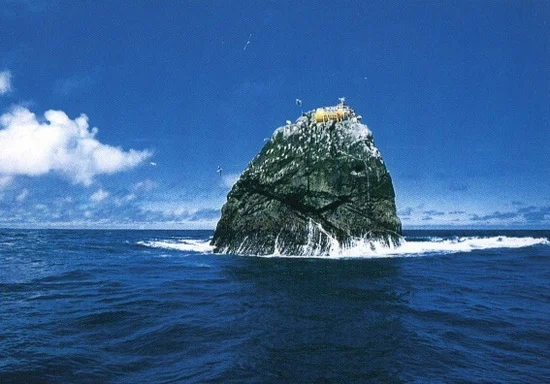
The geographical site of Waveland is more properly referred to as Rockall, a rocky, uninhabited island near the United Kingdom. Its ownership is disputed by the United Kingdom, Iceland, Ireland, and Denmark. In 1997, the environmentalist organizationGreenpeace briefly occupied the island in order to protest oil drilling in the area, declaring it the sovereign new state of Waveland, and offered citizenship to anyone who would take their pledge of allegiance. Since the United Kingdom claims it as its own territory, and since Greenpeace is free to move and operate in the United Kingdom, the UK government had no problem with Greenpeace’s actions and, for the most part, simply ignored them. The protest continued until 1999, when the organization financially backing the project went under. Now, all that remains is a solar-powered beacon to help ships avoid hitting the island.

6. Grand Duchy of Westarctica

Size: 1,610,000 km2
Population: 0, usually
Ruler: Jon-Lawrence Langer, Grand Duke of Westarctica


Westarctica is a wild stretch of Western Antarctica, unclaimed until 2001, when an American by the name of Travis McHenry founded it via a supposed loophole in the Antarctic Treaty, a set of agreements regarding how the international community treats Antarctica. Essentially, the Antarctic Treaty prohibits countries from claiming territory in Western Antarctica, but it does not specifically prohibit individuals from doing so. McHenry claimed his territory, then founded a country. As micronational leaders often do, he sent letters to various world governments informing them of this, but was quietly ignored. Antarctica has no native human population, and as such Westarctica has no year-round citizens. However, some research facilities have been stationed there, and the micronation both prints stamps and mints coins, which are available to collectors for purchase. In 2005, McHenry tried to annex both the Balleny Islands and Peter I Island to grow Westarctica, but nobody really took it seriously – the land already belong to New Zealand and Norway, anyways.

7. Kingdom of Talossa 


Size: 13 km2 , plus a large stretch of Antarctica.
Population: 120
Ruler: King John I

 Flag of the Kingdom of Talossa
14-year-old Wisconsin native Robert Madison founded the Kingdom of Talossa in 1979, initially claiming only his bedroom. As he grew up, he claimed more territory, eventually including a large part of Milwaukee’s East Side and two islands in Antarctica and France. Talossa developed in obscurity throughout Madison’s teen years, but was featured in notable publications like The New York Times and Wired, and subsequently appeared in newspapers and magazines world-wide. Most of Talossa’s “citizens” (more accurately “members”, perhaps) came to know Talossa through Madison’s website. Eventually, some of Talossa’s citizens became frustrated with Madison, suggesting that he had become autocratic and generally intolerable in his actions as leader, which included trumping up false charges of domestic abuse against one of his citizens. About 20 citizens seceded from the micronation, starting their own micronation called The Republic of Talossa. The most recent leader, John Woolley, was chosen in 2007, so this one is still going strong.


This post sponsored by:
Dr Mobiles Limited
1 Huron Street, Takapuna, North Shore 0622
Tel: (09) 551-5344 and Mob: (021) 264-0000
Web - Map - Google+ - Email - Posterous -  Tumblr - Twitter - Blogger - Flickr -  Author    


15 Really Odd Geographical Facts

Our planet is filled with many wonderful geographical and geological anomalies and mysteries. So many so, that we may never truly unlock all of the secrets that nature has tucked away. This is a list of 15 of the more unusual or outright bizarre facts relating to geography, geology, and the earth.

1. Shortest Place Name

The Shortest place name is "Å" it is located in both Sweden and Norway. In Scandinavian languages, "Å" means "river". The image above is one of the newly replaces road signs for the area – they are frequently stolen for their novelty value.

2. Largest City in the World (surface area)
China with Inner Mongolia highlighted in orange and Hulunbuir city highlighted in red
The largest city in the world – based on surface area, is Hulunbuir, Inner Mongolia (China) which is 263 953 km sq (102 000 sq mi).

3. Countries Completely Surrounded by One Other Country
Lesotho
Lesotho, Vatican City, and San Marino are the only countries completely surrounded by one other country. Lesotho is completely surrounded by South Africa, and Vatican City, and San Marino are both completely surrounded by Italy.

4. The Second Longest Geographical Name


The second longest geographical name that is accepted in the world is “Taumatawhakatangihangakoauauotamateaturipukaka pikimaungahoronukupokaiwhe nua kitanatahu” (85 letters) which is a hill in New Zealand – it is a maori phrase which translates to “place where Tamatea, the man with the big knees, who slid, climbed and swallowed mountains, known as land-eater, played his flute to his loved one”. It was the longest until recently (though the Guinness Book of Records still regards it as the longest); it has most likely now been supplanted by Krung thep maha nakorn amorn ratana kosin­mahintar ayutthay amaha dilok phop noppa ratrajathani burirom udom rajaniwes­mahasat harn amorn phimarn avatarn sathit sakkattiya visanukamprasit in Thailand (163 letters).

5. The Coldest and Warmest Sea
 
Persian Gulf 
The White Sea, in Russia, has the lowest temperature, only -2 degrees centigrade. ThePersian Gulf is the warmest sea. In the summer its temperature reaches 35.6 degrees centigrade. 

6. World’s Oldest Constitutional Republic
San Marino
San Marino claims to be the world’s oldest constitutional republic – it was founded in 301 by a Christian stonemason fleeing persecution under Emperor Diocletian. Its constitution of1600 is the oldest written constitution in the world. San Marino is pictured above.

7. The Deepest Hole Ever Drilled by Man
photo source
The deepest hole ever drilled by man is the Kola Superdeep Borehole, in Russia. It reached a depth of 12,261 meters (about 40,226 feet or 7.62 miles). It was drilled for scientific research and gave up some unexpected discoveries, one of which was a huge deposit of hydrogen – so massive that the mud coming from the hole was “boiling” with it.

8. Farthest Point From Earth's Center & Lowest Place on Earth Crust
Mt. Chimborazo    photo source
Due to the bulge of the earth at the equator, the peak of Ecuador's Mount Chimborazo(20,700 feet or 6,310 meters) is the point farthest from the center of the earth so the mountain claims the title of being the "highest point on earth" although Mt. Everest is still the highest point above sea level. Mt. Chimborazo is an extinct volcano and is about one degree south of the equator. 
The Mariana Trench is the deepest part of the world's oceans, and the lowest elevation of the surface of the Earth's crust. It is currently estimated to be up to 10,971 m (35,994 ft) deep. It is located in the western Pacific Ocean, to the east of the Mariana Islands.
 
9. Longest Mountain Chain on Earth

The Mid-Atlantic Ridge is the Longest mountain chain on earth (at 40 000 kilometers or 25 000 miles ). It is located along the middle of the Atlantic. Iceland is the only part of this chain that is above water. The Andes form the longest exposed mountain range at 7 000 kilometers (4 350 miles).

10. Vowel-Only Geographic Locations
Mt. Circeo
Mount Circeo on Cape Circaeum on the western coast of Italy was once called Aeaea (5 vowels in a row with no consonants). It was believed in mythology to be the home of the witch Circe. Two other vowel-only geographic locations are the town of Aiea in Hawaii, andEiao – one of the Marquise Islands.


11. The Most Northern, Eastern and Western State in All of America

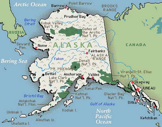
Alaska is the most Northern, Eastern and Western state in all of America. It is the only state that enters the “Eastern Hemisphere” making it also the most eastern lying and western lying state.


12. Sea Without Coasts

The Sargasso Sea is a region in the middle of the North Atlantic Ocean, surrounded by ocean currents, and this is the only sea that has no coast. It is bounded on the west by the Gulf Stream, on the north, by the North Atlantic Current, on the east, by the Canary Current, and on the south, by the North Atlantic Equatorial Current. This system of currents forms the North Atlantic Subtropical Gyre.


13. Lake in an Ancient Meteorite Impact Crater


Lake Bosumtwi, situated within an ancient meteorite impact crater, is approximately 8 km (5 mi) across and the only natural lake in Ghana. It is situated about 30 km (18,6 mi)south-east of Kumasi and is a popular recreational area. There are about 30 villages near the lake, with a combined population of about 70,000 people.

14. Unusual River Flow
River Nile
There is only one River in the world that has its source near the equator and from there flows into a temperate zone - the Nile. For some little understood reason, the flow of most Rivers is in the opposite direction.

15. No Land at the North Pole

There is no land at all at the North Pole, only ice on top of sea. The Arctic Ocean has about12 million sq km (4.6 million sq mi) of floating ice and has the coldest winter temperature of -34 degrees centigrade. 


The 12 of the Most Beautiful Bays in the World!

A bay is loosely defined as a body of water partly enclosed by land. Generally they have calmer waters than the surrounding sea and are a good place for ships to shelter from the weather. Also, bays are often very beautiful and represent unavoidable tourist attractions in the countries where they are located. This is our selection of some of the most beautiful bays in the world, enjoy the post.

1. Wineglass Bay, Tasmania, Australia

link

Wineglass Bay is one of the most secluded, remote bays in the world and consistently ranked as one of the best and most beautiful. Its fame for seclusion is well-earned, as the walk to the beach through woodlands takes about an hour, but is very much worthwhile. Wineglass Bay is actually located near HobartTasmania, an island off the southern tip of Australia, right below Melbourne, Victoria.

link

Freycinet Peninsula, 2.5 hours from Hobart, is the home of Wineglass Bay, and offers natural, breathtaking beauty and plenty of opportunity to bushwalk or hike. The one-hour trek through the woods empties you at the site of a lookout point above the bay. Here, you will witness the vast beauty of the region firsthand, then continue down to the beach itself, marveling at the perfection of it, for a swim in the crystalline waters. On the southern end of the beach watch the Hazards – 300-meter (990 ft) high granite rock sheers – burst into pink flame as the sun sets. [linkmap]

2. Navagio Bay, Greece

Navagio Bay, or the Shipwreck, is an isolated sandy bay on Zakynthos island and one of the most famous bays in Greece. It is notable because it is home to the wreck of the alleged smuggler ship Panagiotis; thus, it is often referred to as 'Smugglers Cove'. Navagio Bay is located on the north-west shore of the Ionian island of Zakynthos (Zante), in the Municipality of Elation.

The area is defined by its sheer limestone cliffswhite sand beaches, and clear blue water, which attract thousands of tourists yearly. The best views of the bay can be seen from a viewpoint platform at the top of the cliffs. Island tour trips stop off here regularly. It is also interesting that the Bay is accessible only by boat.
3. Palm Bay, Australia

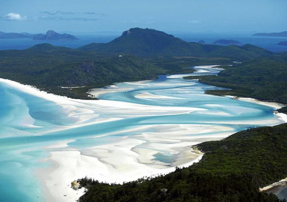
Nestled amongst the swaying palms fringing the white-sand beach and the glistening turquoise waters of Long Island (Whitsunday Islands) lies Palm Bay. A picturesque sweeping bay you can approach it through the dredged channel and lagoon and offers a safe overnight anchorage. From here the visiting yachtsman can take advantage of the bays exclusive and intimate resort, Pepper Palm Bay.

Head further inland and explore the islands National Park by taking one of the many tracks and trails across the islands dense bush and visit some stunning secluded beaches and dramatic headlands whilst experiencing Australian flora and fauna at it’s best.

4. Bay of Islands, New Zealand

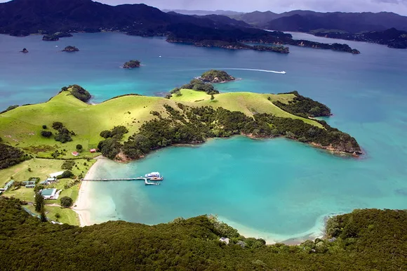
The Bay of Islands is one of the most popular holiday destinations in New Zealand. The picturesque area contains 144 islands, many secluded bays and some great sandy beaches. This beautiful bay has an abundance of marine life including whales, penguins, dolphins and the big marlin.

Urupukapuka Island in the Bay of Islands

Also, this bay is a popular gathering place for sailing yachts on world cruises and international sport fishermen. The bay is also historically significant as it was the first part of New Zealand settled by Europeans. 

5. Hanauma Bay, Hawaii, USA

Hanauma is a marine embayment formed within a volcanic cone and located along the southeast coast of the Island of Oʻahu (just east of Honolulu) in the Hawaiian Islands. Hanauma is one of the most popular tourist destinations on the Island and has suffered somewhat from overuse (at one time accommodating over three million visitors per year). In 1956, dynamite was used to clear portions of the reef to make room for telephone cables linking Hawaii to the west coast of the US.

Hanauma is both a Nature Preserve and a Marine Life Conservation District. Visitors are required by law to refrain from mistreating marine animals or from touching, walking, or otherwise having contact with coral heads, which appear much like large rocks on the ocean floor. About 400 species of fish are known to inhabit the bay. Hanauma Bay is known for its abundance of Green sea turtles, known as Honu. Hanauma is a nursery ground for the immature turtles, which have their nesting grounds at French Frigate Shoals. It is also known for its abundance of parrotfish.

6. Maya Bay, Thailand

link

Maya Bay is a stunningly beautiful bay that's sheltered by 100-metre (330 ft) high cliffs on three sides. Inside the bay there are several beaches, most are small and some only exist at low tide. The main one is around 200 metres (660 ft) long with silky soft white sand, underwater colourful coral and exotic fish in exceptionally clear water; the whole bay is one big reef.

The best time to visit Maya Bay is between November and April during the high season when seas are calm and access to the bay is easy. Rough seas from May to October may hinder access but rarely deny entry.

7. Bay of Kotor, Montenegro

link

The Bay of Kotor in south-western Montenegro is a winding bay on the Adriatic Sea. The bay, sometimes called Europe's southernmost fjord, is in fact a ria of the disintegrated Bokelj River which used to run from the high mountain plateaus of Mount Orjen. It is an important tourist attraction in Montenegro.

The bay is composed of several smaller broad bays, united by narrower channels, forming one of the finest natural harbours in Europe. The bay inlet was formerly a river system. Very intensive tectonics and karstification processes led to the disintegration of this river. After heavy rain the famous waterfall of Sopot spring at Risan appears, and Škurda, another well known spring runs through a canyon from Lovćen (mountain). [linkmap]

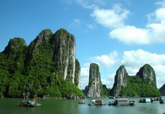
8. Ha Long Bay, Vietnam

Ha Long Bay is a UNESCO World Heritage Site, and a popular travel destination, located in Quang Ninh province, Vietnam. The bay features thousands of limestone karsts and isles in various sizes and shapes. Ha Long Bay is a center of a larger zone which includes Bái Tử Long bay to the northeast, and Cát Bà islands to the southwest. These larger zones share similar geological, geographical, geomorphological, climate, and cultural characters.

The bay consists of a dense cluster of over 3,000 limestone monolithic islands each topped with thick jungle vegetation, rising spectacularly from the ocean. Several of the islands are hollow, with enormous caves. Hang Đầu Gỗ (Wooden stakes cave) is the largest grotto in the Hạ Long area. There are two bigger islands, Tuần Châu and Cat Ba, that have permanent inhabitants, as well as tourist facilities including hotels and beaches. There are a number of beautiful beaches on the smaller islands.


9. Marigot Bay, Saint Lucia

Marigot Bay is located on the western coast of the Caribbean island of Saint Lucia, 3.75 miles (6 km) southwest from Castries and a short distance from the Saint Lucian National Marine Reserve. It is surrounded on three sides by steep, forested hills.


Marigot Bay is a historic landmark, having been the site of a number of battles between the French and British navies. The American novelist James A. Michener famously described Marigot Bay as "The most beautiful bay in the Caribbean."

10. Phang Nga Bay, Thailand

link

Phang Nga Bay is a 400 sq km (154 sq mi) bay in the Andaman Sea between the island of Phuket and the mainland of the Malay peninsula of southern Thailand. Since 1981, an extensive section of the bay has been protected as the Ao Phang Nga National Park. Limestone cliffs with caves, collapsed cave systems and archaeological sites are found about Phang Nga Bay.


Phang Nga is a shallow bay with 42 islands, comprising shallow marine waters and intertidal forested wetlands, with at least 28 species of mangrove; seagrass beds and coral reefs are also present. At least 88 bird species, including the globally threatened Malaysian Plover and Asiatic Dowitcher, can be found within the site, as well as 82 fish species18 reptiles, three amphibians, and 17 mammal species.
11. Hanalei Bay, Hawaii, USA


Hanalei Bay is the largest bay on the north shore of Kauaʻi island in Hawaii. The town of Hanalei is at the mid-point of the bay. Hanalei Bay consists of nearly two miles (3 km) of beach, surrounded by mountains. In the summer, the bay offers excellent mooring for sailboats, stand up paddle boarding and swimming. 


Hanalei means "lei-shaped bay," a fitting description of this almost perfectly circular bay. With over two miles of clean, white sand bordering its inner margin and a backdrop of waterfalls and mountains peaks ranging from 1,000 to 4,000 feet (300-1.200m) high, Hanalei Bay is considered by many visitors and residents to be the most beautiful beach setting in Hawai'i. One of the best views of the beach is from thePrinceville Hotel, located on the bluff above the east point of the bay.

12. Villefranche Bay, France


This bay is one of the most beautiful bay in France. A top place for divers and biggest cruse boats. The bay of Villefranche is one of the deepest natural harbours of any port in the Mediterranean Sea and provides safe anchorage for large ships, reaching depths of 95 m (320 ft) between the Cape of Nice and Cap Ferrat; it extends to the south to form a 500 m (1700 ft) abyss known as the undersea Canyon of Villefranche at about one nautical mile off the coastline.

This post sponsored by:
Dr Mobiles Limited
1 Huron Street, Takapuna, North Shore 0622
Tel: (09) 551-5344 and Mob: (021) 264-0000
Web - Map - Google+ - Email - Posterous -  Tumblr - Twitter - Blogger - Flickr -  Author